


06 Dec When Fire Moves Higher
Wildfires in the Western United States—including the Lake Tahoe region—have been advancing upslope for decades, according to a recent study, moving into elevations previously protected by snowpack, wet conditions and other benefits of altitude
Brian Newman was standing on Echo Summit when the Caldor Fire crested the ridge and moved into the Lake Tahoe Basin on August 30.
At approximately 7,382 feet, the summit does not have a reputation as a path for wildfires. Instead, the Sierra pass and its neighboring peaks are familiar to locals and visitors alike who see photos of the rugged alpine terrain dusted with fresh powder and make plans to ski or snowboard in the area.
Forests covered in white have been a reliable sight for as long as people have flocked to the Tahoe Basin. You’ve seen the pictures: The sky is pale gray, the air is hazy with mist, a dark line here or there indicates a towering pine.
This annual wonderland has persisted throughout innumerable cycles of fall, winter and early spring. Now, however, it has been joined by a new summer twin—albeit a twisted one. California wildfire season creates its own grim parodies of the winter playground images: The sky is gray with smoke, the air is hazy with ash, and any dark lines that are visible represent charred trunks.
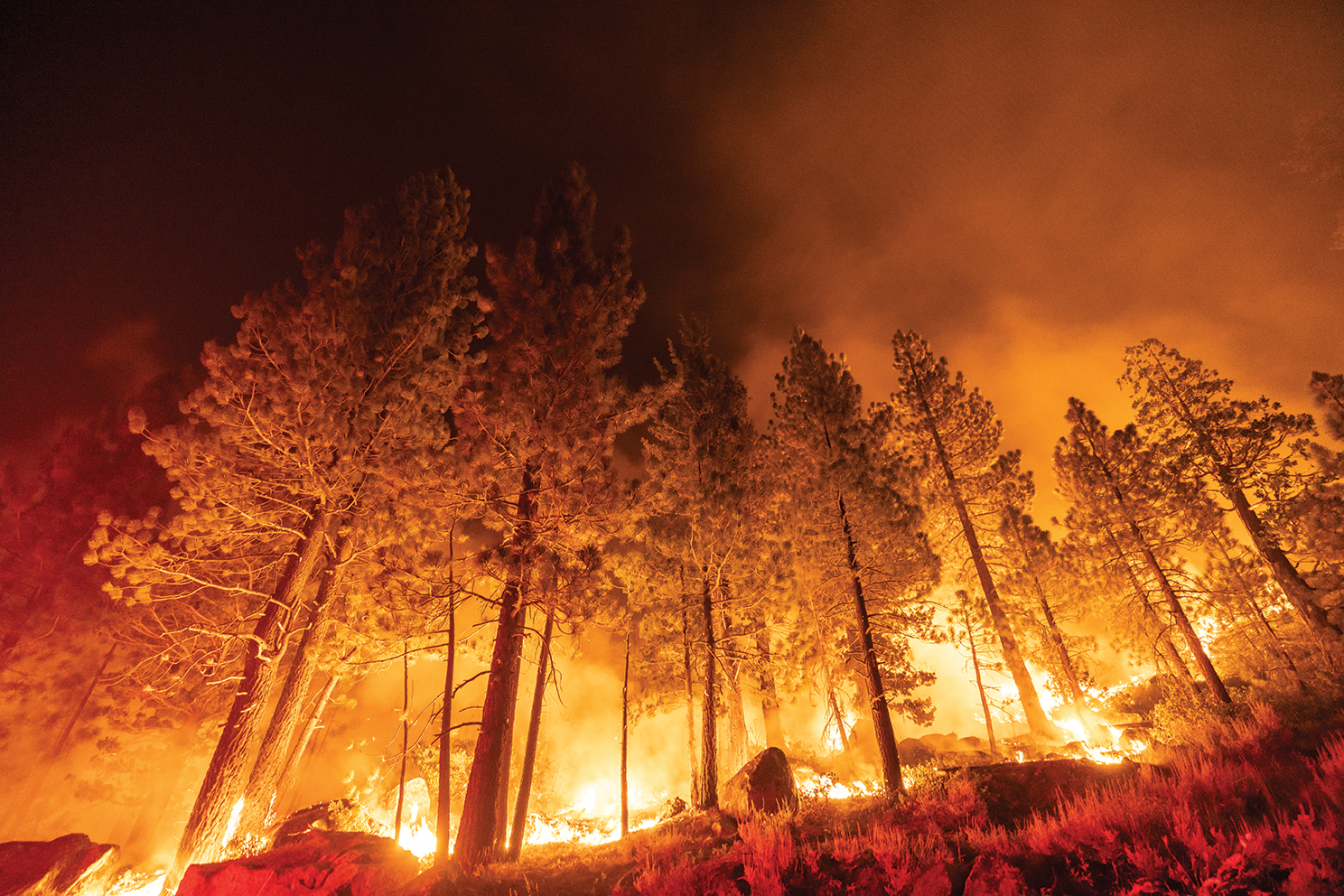
Newman, an assistant fire chief with Cal Fire, saw even more colors that late-August day: bursts of orange blossoming along Highway 50 to the east. These were spot fires, which quickly grew. Soon after, a searing wall of 150-foot-tall flames was roaring through the trees toward Christmas Valley, sending embers ahead to ride the wind and ignite the forest wherever they landed.
Initially, few people believed the blaze that started south of Pollock Pines—a blaze that started anywhere outside the Tahoe Basin—would make it over the massive granite barrier of the Sierra Crest to threaten the lakeside communities. Indeed, as a fire behavior analyst with Cal Fire, Newman had seen predictive models that indicated as much in the Caldor Fire’s early days. Based on projection runs that took available fuel, topography and weather into account, the conflagration would miss the Basin itself.
Over the course of the next two weeks, however, as flames continued to burn north and east, simulations began to show an exponential increase in the risk of an almost unthinkable spread. Crews had to reconsider their strategies and efforts to protect homes and lives. As the fire progressed around the community of Strawberry, Newman’s role on the ground was to strategize, develop tactics and direct Cal Fire’s resources in the Tahoe Basin.
Ultimately, tens of thousands of people streamed out of South Lake Tahoe and the West Shore, fleeing under evacuation orders.
“Most fires in the Basin generally start in the Basin,” says Newman, reflecting on the narrowly averted catastrophe in the days after the Caldor Fire had reached 100 percent containment.
He notes that the area doesn’t have a large fire history, and what fires do spark to life generally have smaller footprints. A wildfire originating outside of the Tahoe Basin and then surmounting the surrounding natural defenses is a rarity, having only happened a couple of times in recorded history.
But could this phenomenon become something more than an anomaly?

A scorched mountainside above Twin Bridges, photo by joSon
The Rise of Wildfires
Half a dozen researchers—ranging from UC Merced to Boise, Idaho, to Montréal, Canada—recently worked together for almost a year to examine more than three decades’ worth of fire information from 15 mountain areas in the Western United States. They published their findings in the Proceedings of the National Academy of Sciences of the United States of America in June, titling their report Warming enabled upslope advance in western US forest fires. Over the course of their study, they discovered that high-elevation forest fires have advanced upslope by a median of about 827 feet throughout the West between 1984 and 2017.
The Sierra Nevada ecoregion saw “a statistically significant increase” throughout that window, according to the report, with blazes reaching about 1,457 feet higher at the tail end of the 2010s than they did in the mid-1980s. Only two other regions—the Southern Rockies and Middle Rockies—saw greater advances.
Mohammed Reza Alizadeh, a PhD student at McGill University in Montréal and the lead author on the upslope study, says the team of researchers came together from a variety of backgrounds, although all were generally related to exploring the impacts of climate change. Their goal was to see if there was a relationship between climate change and the West’s megafires—such as the blazes that scorched California in 2019 and 2020—especially in mountainous areas not known for burning in decades past.
High-elevation forests in California are typically associated with fire return rates that span centuries, the study notes, and that “fire has historically been quite rare” in these ecoregions, which have also been less altered by land use, fire suppression and other direct human activity.
“There are a lot of studies that have shown that wildfires are connected to climate change: The burn area is increasing, the fires are getting worse and larger in terms of frequency, intensity, whatever,” Alizadeh says. “But the point that we really were interested to actually investigate [was] any connection based on those wildfires and the elevations in those mountain areas.”
Alizadeh explains that they were not only surprised to discover climate change pushing fires into higher elevations, but were shocked at the rate this change was happening. The study authors ultimately concluded that the data shows that “fire activity is increasing disproportionally at high-elevation compared to low-elevation forests of the Western United States.”
What does that mean, in non-scientist speak?
Wildfires need dry fuel to burn, whether it’s brush, branches or entire trees. As flames are pushed forward by the wind, they consume whatever’s in front of them until they reach a point where their fuel runs out, either because there’s nothing there to burn (as with bare rock faces or wide strips of land cleared of vegetation) or the potential fuel is too wet to burn (as with rain-soaked soil or trees laden with snow).
Fires also tend to move uphill, often until they encounter what’s known as a “mesic barrier” at some point. “Mesic” refers to an environment with a fair amount of moisture. When flames hit this invisible buffer zone, they can’t really proceed beyond it. Even flying embers carried by gusts do little to create spot fires, because the higher they go, the wetter the fuel—depending on the season, of course.
There are exceptions to this behavior. As a fire advances up a mountainside, convection causes the heat it emits to dry out the ground and vegetation in its path. In this way, a wildfire essentially creates its own fuel by “preheating” the material in front of it. Still, this only works up to a point, since saturated soil and water-laden plants can better hold out against combustion until the fire burns itself out or is extinguished by precipitation.
That point, however, is moving. Alizadeh and his fellow authors found that the mesic barrier had retreated rapidly across the map—disappearing entirely in some places.
A nearly 1,500-foot rise in the mesic barrier in the Sierra Nevada region means wildfires now have access to much more potential fuel. The study authors estimate that increasing aridity throughout the ecoregions they studied have made an additional 31,467 square miles of Western wildlands accessible to burns.
The mesic barrier’s rise also means that fires are increasingly able and likely to get up and over peaks that formerly kept them out of the valleys below. While this was never an impossibility before, it’s certainly more of a possibility now for a multitude of reasons: generally warmer conditions, longer snow-free periods, a retreating snowpack, less rain to curtail fire season during prolonged drought periods, and more. The wind that zips over ridgelines can easily grab an ember and carry it miles away—and each ember represents a potential new blaze.
Cal Fire’s Newman read Alizadeh’s study shortly after it was published and says it is generally accurate. These days, he says, “snow levels don’t generally drop as low downslope on the Sierra Nevada as they did in the past.” A few decades ago, potential fuel for fires in the 4,000- to 6,000-foot elevation range was covered in snowpack for longer periods of time.
“Now, it’s much less covered—if covered at all—in the Tahoe area and West,” Newman says.
The less time fuels spend under snow, the more time they have to dry out in the sun—like curing cordwood. This makes them more available to burn earlier in the season. Consider, too, that the drier the fuel, the more receptive it is to fire, and the more intensely it burns.
Higher elevations also tend to have more timber and less brush. Trees, in particular, store considerable energy that is released when they burn. Newman explains that a change in fuel density with altitude also changes the behavior of fire itself by increasing opportunities for blazes to progress from the ground to torching groups of trees to advancing upward into a crown run—which happened in places during the Caldor Fire. This is when flames move along the tops of trees, sometimes creating a wholly separate fire from the one burning several stories below. Crown runs sound like freight trains, Newman says, and they completely darken the sky. They can even create their own localized weather, with plumes of smoke and heat triggering downdrafts and lightning.
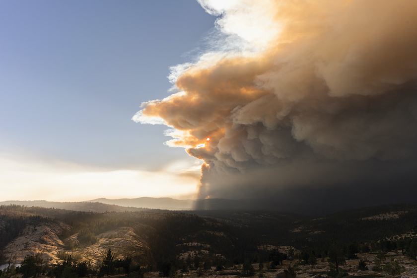
The Caldor Fire produces a giant plume of smoke on its uphill march toward Echo Summit, photo by David Braun
The Why of Wildfires
At this point, we should address the elephant in the forest. While many researchers and leaders pin the blame for modern wildfire intensity and frequency on climate change, plenty of people who live and work in forested areas either threatened or decimated by wildfire blame restrictive forest management policies for creating unprecedented stands of ready fuel. There’s an acronym—FRID—that stands for Fire Return Interval Departure, which refers to the difference in how often fires burned freely or semi-freely in pre-settlement times versus now. The idea is that relatively routine blazes in pre-1900 California were only hot enough to clear out brush and similar low-lying fuel, preventing future fires from finding ample material that could stoke them even hotter, send flames into the more vulnerable canopies and cause lasting destruction.
Several sources approached for this story were wary from the beginning, hesitant to wade into any discussion of fire—even if the focus was on what upslope advancement might mean for the Tahoe area. “Your readers may not like hearing it, but poor forest management in the Sierra is more detrimental and impactful than climate change,” one wrote.
Still, an investigation into what’s driving fires higher is necessary, if daunting. Looking into a reason behind the West’s recent string of record-breaking fire seasons takes you far into a past dotted with natural blazes from lightning strikes and cyclical native-driven burns, through more than a century of forest-altering fire-suppressing regulations, and into a time of international summits focusing on a warming earth and the threats of tomorrow.
Even the upslope study authors acknowledge the complexity of the situation. While their conclusion is that the elevation changes in wildfires are “largely a byproduct of climate warming,” they also point out that “a century of fire exclusion efforts is hypothesized to have partially contributed to this trend.”
Craig Thomas, director of the Fire Restoration Group in California, points out that we—meaning humans in the West—have always lived with fire, although conditions were generally more stable until relatively recently.
“So the earth is rotating through its axis since forever,” he says. “We’ve had fairly extensive cold periods and warm periods … and we’ve never lived through one of those. I’m talking an Ice Age—really cold, and [then] really hot and dry. We may be headed for one, but we’ve never done this dance while burning fossil fuel for 170 years. So that’s the thing that’s really new and exacerbating the uphill movement and the expansion of the fire seasons.”
In other words, the best explanation for the upslope advance may be that climate change is the significant driver of wildfire explosions in a drought-crisped West—responsible for everything from shrinking snowpack to sometimes turning the atmosphere into a dry sponge that wicks moisture out of the very ground and plants below—but fuel accumulation due to suppression efforts certainly hasn’t helped.
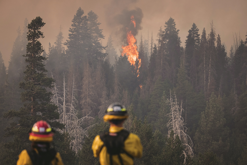
Firefighters look on from Caples Lake, located near Kirkwood at about 7,800 feet in elevation, as the Caldor Fire rips through a thick stand of trees, photo by Brian Walker
The Benefit of Wildfires
Thomas’ Fire Restoration Group is a nonprofit working to put fire back in its proper place. That means, at least in part, using or allowing fires to shape local forests as they did in the 1800s and earlier, whether ignited accidentally by lightning or intentionally by native populations. The group’s website explains that fires returning at regular rates minimized fuel loading in the forests and encouraged vegetation to adapt with resilience.
Using beneficial fire today often means prescribed burns, carefully sited and monitored to clear out dense stands of fuel without creating a raging inferno that takes out trees that have survived who knows how many lesser wildfires in the past.
In considering what the more recent upslope advancement of wildfires could mean for the Fire Restoration Group’s efforts, Thomas theorizes that workers can potentially burn more in seasons not typically suited for fires.
“Not that we don’t want rain and snow,” he says. “We want those elements—which are a natural part of the system, just like fire is—to be present, and we want the world to be what we’ve remembered it to be, right? When it changes that dramatically, it gets everybody amped up, and that’s understandable. But up there at that elevation, say in the Tahoe Basin, that may open up opportunities [for burning], when normally it would be snow-covered and wetter.”
In other words, if damaging wildfires are gaining more access to higher-elevation regions, so are crews who can implement strategies to mitigate them.
“But the thing that is critical is: Do we have the workforce available at the time?” Thomas adds. “… We need to have that workforce ready and available, trained and ready to go to take advantage of any opportunity when it’s safer to burn in places like Lake Tahoe. And we don’t currently have that workforce.”
One of the big problems in this regard, he says, is that the current fire suppression workforce is growing increasingly busy in their efforts to protect life, homes and other property, and natural resources.
“I think everybody agrees they were totally maxed out this year,” Thomas says. “And we’re talking about young people that are breathing smoke for months and working their tails off on extremely long shifts. … We’re asking more and more of them, and we’re hitting the maxed-out mark, so when they come home exhausted, say, in November … how do we ask them? They have family at home, they have children … and then we ask them to do ecological burning for us during the offseason, when they need a break.”
Thomas believes in the need for a much broader workforce trained to carry out prescribed burns, particularly in places where fire resilience has already been created with taxpayer money and human capital. The Tahoe Basin has seen a lot of intentional fire work, he adds, “and we don’t want that to unravel again, into instability.”
One of Thomas’ current big pushes is for the creation of a prescribed fire training center for the state, featuring multiple field campuses that teach crews to burn landscapes they are familiar with, as well as other California locations with different fuel types, topography and seasonal nuances. He admits that prescribed fires are complicated—but so is the current fire situation, both socially and ecologically.

Firefighters work to contain the Caldor Fire as it burns into the granite terrain of Desolation Wilderness, photo courtesy Cal Fire
The Future of Fighting Wildfires
“It’s a fact that we need to continue our fuel-reduction efforts,” says Newman.
With 26 wildfire seasons behind him and many more dry years ahead, the fire behavior analyst has been assessing what went right during the Caldor Fire. He cited one burn effort in particular as a turning point: “When this fire hit a large prescribed fire area … it made an effective change in the fire behavior south of Strawberry, between Silver Fork Road and along Cable Street Drainage.”
With this in mind, he emphasizes that projects dedicated to thinning trees and prescribed fires are integral for a safer tomorrow.
He also includes informed and proactive community members among factors that mitigated the Caldor Fire, as well as July’s lightning-sparked Tamarack Fire in the Humboldt-Toiyabe National Forest. There is a robust defensible space program, he says, that educates locals on how to clear vegetation and create space around their dwellings. His and other agencies also teach about “home hardening,” which encourages the use of noncombustible roofing material and other anti-fire construction and improvement strategies.
Above all, buy-in from communities who see a changing environment and want to adapt their thinking and behavior may be the most potent weapon in the fight against wildfires—upslope, downslope and anywhere. This is not a Tahoe Basin problem, but one that reaches even those international citizens who see historic photos of snowy Echo Summit and dream of Lake Tahoe as a place to visit for skiing, for trekking beneath the trees, for enjoying natural wonders that have lasted and will continue to last if properly cared for.
There is no doubt that vast swaths of land that were unlikely to burn previously are now vulnerable. The question is: What will we do in response? Can we help forests increasingly challenged by megafires by looking to fire regimes of the past, adapting our thinking and moving forward?
“We tend to have—until recently—always tried to commodify our relationship with nature,” Thomas says. “And I try to get people to rethink that and understand that our primary product is resilience. And if we behave ourselves, we may be allowed to enjoy some of the other benefits. But without resilience, we’re going to be in big trouble. And we are in big trouble.
“So, to me,” he continues, “that’s the important message: We have to concentrate on building resilience in these landscapes and [understand] that while we’re dealing with CO2 emissions and burning down forests and all the other things, all of that fits together into one big challenge—but it’s the resilience part that we need to aim at. Carbon stability comes from that. Watershed protection comes from that. Community protection comes from that, and better public health than if we’re burning all summer long and inundating towns with smoke for months on end. All of that is tied to resilience.”
Ryan Miller is a writer living in the Sacramento area. Follow him on Twitter or Instagram, @jesteram.
No Comments