


01 May Ripe for the Harvest
Tahoe’s corn snow is legendary, and this year it promises to last well into the summer
While Iowa produces the most corn in the United States and Olivia, Minnesota, declares itself the corn capital of the world, Lake Tahoe takes the crown as home to one of the most unique corn harvests in the country. This season delivered a bumper crop, which skiers and snowboarders will be harvesting long into the summer.
Corn snow—formed by a combination of precipitation, temperature, solar radiation and wind—is coveted by skiers for its soft, consistent surface. Its large rounded grains resemble corn kernels pulled off the cob as the result of a repetitive melt-freeze cycle common during the spring and summer at higher elevations. While nature takes much of the hard work out of raising Sierra corn, correct harvesting by late-season backcountry skiing enthusiasts takes careful timing and planning.
The Tahoe Basin received more total snowfall by mid-February this year than all of the 2017-18 season, assuring that patches of skiable snow will exist well past spring. While information regarding backcountry skiing in the Tahoe region is easily accessed through a number of avenues, including guidebooks (Jeremy Benson’s Backcountry Ski & Snowboard Routes: California), online reports (State of the Backcountry by Brennan Lagasse) and social media, this article serves as a starting point for springtime backcountry skiing adventures. The following locations around the lake are known to hold quality snow late into the season, particularly during banner years such as this.
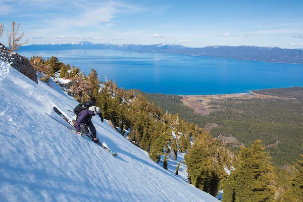
Brennan Lagasse finds quality turns on Castle Peak, which is known to hold its snow deep into the season, photo by Ryan Salm
Castle Peak
Distance: 4 miles round-trip
Castle Peak towers over Interstate 80 on Donner Summit, topping out at just over 9,100 feet. Akin to its medieval namesake, this formation of cliffs resembles the towers and turrets of stone castles and can often hold its treasure trove of good snow late into the season thanks to its high elevation.
The longest-lasting corn snow is found beyond the mile-long east-west ridge, where the snowpack is sheltered from the sun. The runs down the gullies spread across Castle Peak’s north face are short enough to encourage multiple easy laps, leaving enough energy to make the short return trip back to the car.
To storm Castle Peak in search of the riches it might hold, head west on I-80 from Truckee and park at either the “sno-park” off the Boreal exit or, if open, the dirt lot on the north side of the Boreal Ridge Road exit. Regardless of parking location, begin the tour on the north side of the interstate by following the U.S. Forest Service road parallel to Upper Castle Creek for about a mile until the road deviates from the creek drainage. At this point, turn directly north and follow the drainage up the prominent chute on the south side of Castle Peak.
There are two choices from the summit: Drop into the north-face gullies via a short hike along the ridge or, if snow levels permit, retrace the skin track back down the longer south chute to the parking area.
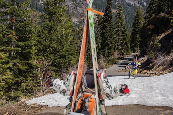
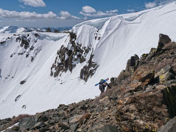
When Barker Pass Road is closed by Highway 89, snow-seekers often use bikes to access the Fourth of July Chutes, photo by Ryan Salm
Rylan Cordova harvests corn in Fourth of July Chutes in Blackwood Canyon, photo by Ryan Salm
Blackwood
Canyon Cliffs
Distance: 2 miles round-trip, 16 miles if the gates are locked down to Highway 89.
The Fourth of July weekend can be crowded and hot in the Tahoe Basin, which makes the aptly named Fourth of July Chutes at the top of Blackwood Canyon on the West Shore the perfect place to escape the crowds and cool off in the snow. The elevation and north-facing aspect of these chutes result in some of the longest-lasting snow in the area, making these ski runs a safe bet late into summer.
From Tahoe City, drive south toward Homewood on Highway 89, stopping at the sno-park just north of the resort. The length of the approach up Blackwood Canyon varies depending on the condition of Barker Pass Road, but many folks have been known to ride their bicycles up to snowline when the gate is closed by Highway 89. The 7-mile bike ride can be avoided by arriving late enough in the spring or summer that the road to Ellis Peak trailhead is open.
From the trailhead, follow the trail south up to the prominent ridge, then follow it east. While touring along the ridge, the Fourth of July Chutes will appear below on the north aspect. Ski down whichever chute appeals most, bootpack back up to the ridge and repeat. Ideally, enough snow is present in the trees north of the chutes to ski back to the car. If not, a walk through the woods never hurt anyone.

Alec Bowman and Alex Spencer make their way up the south face of Jakes Peak to enjoy some spring snow above Emerald Bay, photo by Brian Walker
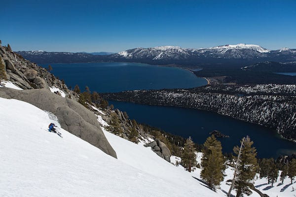
Alec Bowman enjoys the view and spring corn snow as he carves turns down the south face of Jakes Peak, photo by Brian Walker
Jakes Peak
Distance: 3 miles
The most difficult part of descending Jakes Peak is focusing on the line rather than the stunning view of Emerald Bay and the rest of Lake Tahoe below. This panoramic beauty comes with a caveat: Many exposed aspects of the peak tend to melt faster than other zones, resulting in a much shorter, yet high quality, corn skiing season. The northern aspect of Jakes Peak typically has a longer-lasting snowpack if conditions are grim.
The approach to Jakes Peak differs depending on the targeted aspect. For north-side approaches later in the season, begin at the pullout just below D.L. Bliss State Park and look for a skin track to follow. In the rare case a skin track is not present, tour directly west through the trees until reaching a topographic bench at 7,700 feet in elevation. From here, the summit of Jakes is visible to the south. Aim for the summit up the ridge, crossing over to the east face once at the top. Below is the East Bowl, known locally as Avy Path, providing a few thousand feet of quality corn descending.
South Jakes is quite similar in approach to its northern half, although the summit is in view from the beginning. Park at the pullout on the west side of Highway 89 just above Vikingsholm and follow the fire road southwest for a few hundred feet before turning west and heading directly up the gully toward Jakes Peak. The skin track here is often steep in order to preserve as much snow as possible for the route down, which parallels the ascent.
Jeremy Davis ascends a ridge on Mount Tallac, photo by First Tracks Productions
Jason Layh finds the last of spring’s goods on the flanks of Mount Tallac, photo by Ryan Salm
Mount Tallac
Distance: 6 miles
Mount Tallac is hard to miss above the southwest shore of Tahoe. The peak dwarfs those around it, with its broad east and west faces separating the Tahoe Basin from Desolation Wilderness. The sheer size of the peak lends itself to having something for everyone: some of the longest descents in Tahoe, wide-open bowls, glades and steep, technical terrain. If corn is desired, the south-southeast face known as Cathedral Bowl is the place.
Depending on snow conditions, the beginning point for this tour may vary. If snow levels are high enough that the gate to Spring Creek Road is closed, park at the pullout a few hundred feet south on Highway 89. If the gate is open, follow Spring Creek Road up for about a mile until it ends beyond the cabins.
At the last fork in the road, enter the forest and head southwest for less than a quarter mile, at which point the lower slopes open up, affording a view of the ridge that runs down the middle of Tallac’s east face. Head toward the aforementioned ridge, staying on the north side of the small creek running parallel, but below the ridge. Once at the base, stay on the north side of the ridge and ascend about 2,000 vertical feet to the main north-south-running ridge of Mount Tallac. Moving south along this main ridge toward the summit, take a moment to appreciate the highest point along the West Shore of Tahoe, allowing for panoramic views of the lake and Desolation Wilderness.
To ski Cathedral Bowl from the summit, continue an additional quarter mile south of the summit to the top of this bowl and enjoy the 1,600-foot vertical descent toward Floating Island Lake. Before reaching the shallow gradients surrounding the lake at around 8,000 feet, stop and turn around for another lap of the bowl, or traverse along the contour north until reaching another bowl with a creek running northwest through it. Descending this drainage, known as North Bowl, brings skiers back to their original skin track.
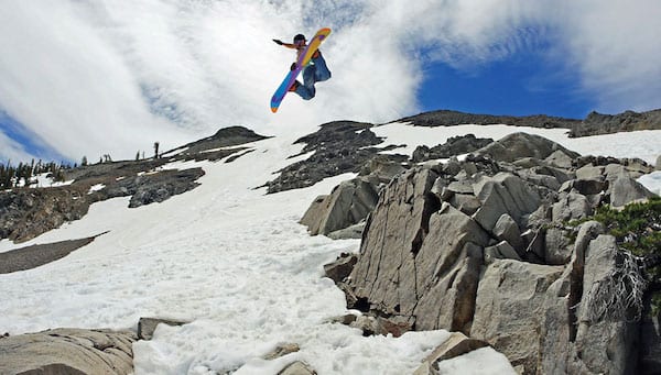
Alex Miller launches off a feature at “The Patch,” photo by First Tracks Productions
“The Patch”
Distance: Varies
While the name itself implies a mystical secret, the area known fondly as “The Patch” is simply a basin at the end of a dirt road with an abundance of snow fields (or patches of snow) that vary in size and number throughout the spring and summer. The area is known to harbor some of the longest-lasting snow in the region.
Be warned: The condition of the dirt road that accesses The Patch changes often, from lightly snow-covered to high clearance mandatory. The Patch is an easy day trip for South Shore residents, but consider bringing a tent and some barbecue supplies when planning a longer stay, as this area is worth exploring.
From South Lake Tahoe, head down Highway 89 to Meyers and continue south to Markleeville. From there, turn right onto Highway 88. Several miles down 88, a dirt road veers left of the highway. This is the entrance to The Patch. Follow the road to its terminus, which is surrounded by granite cliffs, grassy meadows and a few gullies holding patches of corn snow for the harvesting. The popularity of this area often leads to parties building jumps and placing PVC pipe on some patches of snow to build small private terrain parks.
Silver Peak
Distance: 6 miles
While there are countless objectives both north and south of Tahoe, Ebbetts Pass and Sonora Pass are both close enough to be considered a feasible day trip, or a good stopping point on trips farther away.
Before embarking on a mission to Ebbetts Pass, check road conditions, as this road is one of the last to open. Snow fields and peaks dot either side of Ebbetts Pass, but Silver Peak, elevation 10,772 feet, dominates the skyline east of the pass, up Noble Canyon. Skiing Silver Peak is no easy journey, with the longest approach of any other location mentioned here, and an elevation gain of roughly 4,000 feet.
The terrain found on Silver Peak matches the difficulty of the journey, in that the primary descents down Silver Peak are steep and narrow chutes. The most prominent of these chutes, Northwest Chute, is the most sought after, as it drops skiers down almost 2,000 vertical feet through an aesthetic couloir with high walls on either side into a wide snowfield.
Another option is to drive to Markleeville, following Highway 89 south for almost 5 miles until the junction between Highway 4 and Monitor Pass. Head west for 8 miles to the Noble Canyon trailhead parking. In sneakers or ski boots, depending on snow level, follow this trail uphill along the west side of the creek for a half mile, where scouting begins for a suitable place to cross the creek.
Once across the creek on the east bank, head southeast along an undulating ridgeline. The south summit of Silver Peak becomes visible, illuminating the remainder of the route up the east-facing ramp. Head north at the summit along the ridge to the top of the Northwest Chute. The entrance is rather obvious as it marked by a wide hourglass face at the top that narrows into a chute several hundred feet below. Once below the chute, contour skier’s left (west) to follow the ridge back to the creek crossing and trail back to the car.
Skier’s Paradise
The locations described in this guide are just the tip of the iceberg. With many peaks above 12,000 feet in the Sierra, and a handful over 10,000 feet in the Tahoe Basin, there are countless options to explore in search of good skiing and riding.
Once comfortable accessing these backcountry locales, pick your favorite trailhead and go out in search of your own personal patches of snow that are ripe for the harvest.
Dillon Osleger is a skier, cyclist and earth scientist based out of Truckee. Always keen to merge his passions for science and the outdoors, he can usually be found on the skintrack, trail or river.
Safety and Etiquette
• Backcountry skiing is an inherently dangerous sport, combining the risks of skiing and avalanche hazard. This guide is not a substitute for careful planning, professional training or good judgement.
• Backcountry etiquette is important: Dispose of waste properly, respect wildlife and be considerate of others. An additional rule of etiquette often imposed during spring and summer skiing is to regard snow conditions and preservation. Skiing corn snow late in the day after it has been warmed to the point of slush will result in channel formation, deteriorating snow depth and terrain quality. It is best to ski corn between 11 a.m. and 2 p.m. to avoid the early-morning ice crust and the late-evening slush.
No Comments