


04 Feb Desolation Wilderness: Cherished and Guarded
Popular wilderness ages well under the eye of devoted stewards
Desolation is a relative term. In the case of Lake Tahoe’s prize slice of backcountry real estate, the designated expanse of scenic, jagged peaks, rock-coated valleys and lakes of gin-clear quality earned the moniker from its barren appearance—a land thin on the forests cloaking neighboring terrain, and without a human soul in sight.
“It was desolate. You’d look around and all there was was this huge, stark canyon of glacial-polished rock,” says Don Lane, a veteran Forest Service ranger and longtime manager of Desolation Wilderness, speaking about U.S. Geological Survey mapmakers around the turn of the 20th century.
That was then. Now, the nearly 64,000-acre jewel is desolate only in the treeless sense, as it ranks among the United States’ most traveled wilderness areas.
Yet, due to a strict zoning quota system and regulations enacted to preserve the land, Desolation remains a natural wonder deserving of acclaim by the most seasoned backcountry adventurers.
“I would rank it highly,” says Jack “Found” Haskel, a through hiker and trail information specialist with the Pacific Crest Trail Association, comparing Desolation Wilderness with other sections of Pacific Crest Trail between Mexico and Canada. “In Desolation, you get these fantastic granite slabs and nicely colored rock terrain. It’s a taste of high country—a really nice section of the trail.”
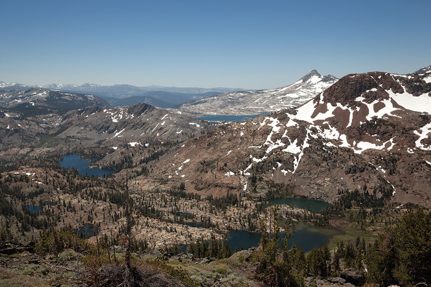
Averaging 12.5 miles in length and 8 miles in width, Desolation Wilderness spreads out along the Sierra Crest above the southwest corner of Lake Tahoe, ranging in elevation from about 6,500 feet to 9,983 feet at Pyramid Peak’s summit. The wilderness area contains a web of hiking trails, highlighted by the Pacific Crest Trail (and coinciding Tahoe Rim Trail) splitting it north to south.
Visitors to Emerald Bay—a bustling hotspot in summer months—can catch a tantalizing glimpse into the gaping mouth of Desolation, framed between the steep slopes of Jake’s and Maggies peaks, while those willing to break a sweat can venture into the belly of the wilderness area with a short hike up Eagle Falls Trail to Eagle Lake.
Once inside, evidence of Desolation’s glacial history abounds, from miles of smoothed, bald terrain—shorn to its granite shell—to bowl-shaped valleys and alpine lakes. The natural forming process didn’t skimp on lakes. Some 130 of them, as large as 900 acres in size, lie within the wilderness boundary, making the area that much more enticing for human exploration—hence the high volume of foot traffic.
Well-Trodden
Squeeze that traffic into a limited number of popular hiking and backpacking destinations, and Lane’s assessment of Desolation as perhaps the busiest wilderness area per square mile in the country is palpable.
“The problem is, it’s not that big when you start putting people into fairly limited areas. We have almost 100 square miles of land, but realistically, people concentrate in probably a half a dozen areas,” Lane says. “Part of the reality for us wilderness managers is a thing called ‘opportunities for solitude.’ In theory, you don’t want to go into a wilderness area and see mobs of people.
“So the response to that by the Forest Service is a lot more restrictions and constraints, almost out of desperation, to maintain the character of Desolation. Group size limits, no campfires, things like that, we had to reluctantly adopt over the passing decades.”
It’s why today, anyone entering Desolation Wilderness overnight is required to purchase a wilderness permit. There’s also an overnight quota system based on the number of people entering the wilderness each day. Visitors must choose a first-night destination among 45 designated zones, and they must keep their group size to 12 people or fewer.
“It does get crowded. But they have a very good and very beneficial quota system,” says Haskel, who passed through Desolation Wilderness in early July 2006 when he through-hiked the Pacific Crest Trail. “It’s well managed, so even though there are a lot of people, you don’t have someone right next to you.”
A Need to Protect
Given its close proximity to the masses—just hours from the San Francisco Bay Area and butted up to South Lake Tahoe—conservationists recognized early on the need to preserve the land.
The Desolation Wilderness region was established in 1899 as part of the Lake Tahoe Forest Reserve, according to the U.S. Forest Service. Once motorists started making their way over Echo and Donner summits, the land became part of the newly formed Eldorado National Forest.
The name changed to Desolation Valley Primitive Area in 1931, and in 1969, Congress adopted Desolation Wilderness into the National Wilderness Preservation System. It’s managed according to the Wilderness Act of 1964 to “ensure an enduring resource of wilderness for present and future generations.”
By 1973, about the time Lane joined the Forest Service ranks, management divided into two forces. The Lake Tahoe Basin Management Unit managed the east side of the wilderness area. The Eldorado National Forest managed the west side.
“Tahoe had so many Forest Service offices managing it, they just needed to simplify it,” says Lane, who has worked as a ranger with the Lake Tahoe Basin Management Unit for 40 years. Although it manages less land, the Lake Tahoe Basin Management Unit far exceeds the amount of trail usage in the Eldorado National Forest, Lane adds.
“We have about 21,300 acres, or one-third of the total, but we have about two-thirds of the total use, because we’re on the Tahoe side,” Lane says.
Easy Access
Desolation is accessible from 15 trailheads. The most popular include the Eagle Falls and nearby Bayview trailheads, both of which climb out of Emerald Bay, as well as the quintessential Desolation hike from the Echo Lakes Trailhead to Lake Aloha, near the southern reach of the wilderness area. Other entry points within the Lake Tahoe Basin Management Unit include the Glen Alpine, Mount Tallac and Meeks Bay trailheads.
Those entering along the Pacific Crest Trail at Echo Lakes may choose to take a water taxi across Lower and Upper Echo lakes before embarking on the rocky, exposed stretch to Aloha, which offers relief in side hikes to Tamarack, Ralston and Cagwin Lakes, Lake of the Woods, and lakes Margery and Lucille.
The largest body of water in Desolation Wilderness, Lake Aloha, varies drastically from spring melt-out to fall. The sprawling, granite-rimmed lake, which fills the heart of the 8,116-foot Desolation Valley, didn’t previously exist. Instead, the area formerly termed the Devil’s Basin once consisted of several small natural lakes, called Medley Lakes. A rock dam was constructed in 1875—and later raised—to pool the water from Pyramid Creek.
“They started damming up that huge open canyon of glacial desolation. And when the water started coming in, the name eventually evolved to Lake Aloha,” Lane says, explaining water from the lake is released in the fall as part of the Upper American River Project, feeding power and water to the Sacramento Valley.
As such, picturesque Lake Aloha—surrounded by the towering Pyramid Range to the west, Jack’s and Dick’s peaks to the north and the backside of Mount Tallac to the northwest—dries up late in the season, revealing hundreds of small islands.
The Eagle Falls and Bayview trailheads, meanwhile, reward travelers in quick order with stellar views overlooking Emerald Bay and Lake Tahoe. To reach those views, however, both trails gain significant elevation from the start, with Eagle Falls Trail reaching its namesake along Eagle Creek in just 0.2 miles.
The granite-bound Eagle Lake is less than a mile from Eagle Falls Trailhead. The trail continues its climb upward until it merges with the Bayview Trail some 3 miles from the trailhead. Here, hikers can drop into Azure Lake, Dick’s Lake, Fontanillis or the upper, lower or middle Velmas.
The Meeks Bay Trailhead—also known as the Tahoe-Yosemite Trail—enters Desolation Wilderness from the northeast corner, and is used to reach the Velma Lakes. This moderate trail reaches Lake Genevieve in about 4.6 miles and continues past Crag, Hidden and Shadow lakes before reaching Stony Ridge Lake, at the eastern base of Rubicon Peak.
The Meeks Bay Trail then sends its travelers up and over Phipps Pass, where an expansive, jaw-dropping view opens up across the interior of Desolation Wilderness—peering down on the blue puzzle pieces of the Velmas, across their glacially carved valley to Dick’s Peak and Mount Tallac, and beyond the Rockbound Valley to the Crystal Range on the western edge of the wilderness.
The Mount Tallac and Glen Alpine trailheads are both near Fallen Leaf Lake, between Emerald Bay and Echo Lakes.
The Glen Alpine Trail, which accesses Susie, Heather and Grass lakes, among others, is difficult to reach, as hikers must negotiate a rough one-lane road along the south side of Fallen Leaf Lake to the parking area near Lily Lake. The tough drive makes this trailhead ideal for those seeking to avoid heavy crowds.
Fishing Desolation
Unfortunately for angling hikers, fishing is on the decline in Desolation Wilderness. Trout plants the lakes received since the late 1800s screeched to a halt with the introduction of the Sierra Nevada Yellow-Legged Frog Habitat Restoration Project, which began in 2008. The project intends to restore Desolation’s lakes to a fishless state in order to bolster the native population of frogs that suffered as a direct result of fish.
“Over time, the fish managed to feed their face with a lot of frogs, and no one cared as long as they caught their limit of fish,” Lane says. “But then the Forest Service stepped in and said, ‘Wait a minute, we want to establish the natural condition of the area up here.’ So the frogs are quietly croaking their way back, and somehow some of them managed to survive the onslaught of those voracious trout—not in every lake, but a lot of them.”
As part of the Sierra Nevada Yellow-Legged Frog Habitat Restoration Project, biologists with the Lake Tahoe Basin Management Unit, along with the California Department of Fish and Game, used gill nets to remove the various trout species from selected lakes.
Plans are under way this summer to use gillnetting and electrofishing in the same lakes that were previously treated—Tamarack, Ralston, Cagwin, Lake Margery and Lake Lucille, plus Le Conte and Jabu, according to U.S. Forest Service reports.
Nevertheless, fish still populate most of Desolation’s lakes, including rainbow, brown, brook—the most common catch—and golden trout, and even mackinaw in a few waters.
“I think Desolation has got its areas that are really good, and its areas that used to be really good,” says Victor Babbitt, owner of Tahoe Fly Fishing Outfitters in South Lake Tahoe. “They’ve taken fish out of certain fisheries up there because of the yellow-legged frog. That’s changed a few of the lakes, but I think the fishing can still be fantastic.”
Babbitt’s favorite lakes to fish are Snow Lake and Cup Lake, near Ralston Peak, as well as the Velmas, Susie, Heather and Grass lakes, which produce nice brown trout. Cup, Saucer and Dick’s Lakes boast golden trout, while Gilmore Lake near the western foot of Mount Tallac and Stoney Ridge Lake contain mackinaw, Babbitt says.
John Read, a longtime Truckee resident and avid fisherman, tells a story of the big one that got away at Heather Lake, a small but deep body of water north of Lake Aloha. He hooked a nice brook trout, and upon reeling it in was shocked to see a “huge brown” emerge from the depths in pursuit of his catch, only to spot him and his fishing partner and dart away. “He saw us and said, ‘I’m outta here,’” Read recalls.
Although he still goes after the Heather Lake brown that got away, Read most enjoys fishing the Velmas, which also provide fine overnight camping.
Asked if he had a favorite fish story from Desolation Wilderness, Babbitt recounts a time in the mid to late 1980s when he landed a colorful fish in the small creek between Snow and Azure lakes, near Mount Tallac.
“It was probably 25 to 27 years ago—I caught what I thought was golden. It had the markings with the white line on dorsal fin, but it may have been a cross breed,” he says. “It was about 12 inches, but it was just a super gorgeous fish. That’s a fish I’ll never forget.”
For the novice angler or those with time constraints, Babbitt says Eagle Lake is a convenient option.
“It’s not the most spectacular fishery in the world, but there are times of the year, especially the ice-out in the spring, that it fishes really well,” he says, adding anglers often haul in a one-man float tube to the closer lakes.
A Winter Wonderland
With such an impressive array of peaks, locals and visitors alike take full advantage of backcountry skiing opportunities in Desolation Wilderness.
Scott Longoria of Tahoe Sports Ltd. says skiers frequent the slopes of Mount Tallac, which towers over South Lake Tahoe at 9,735 feet, as well as the steep pitches surrounding Emerald Bay. He notes Ralston Peak, at 9,235 feet and located in the southern tip of Desolation, is another popular backcountry ski destination, as is the 9,983-foot Pyramid Peak—Desolation’s tallest.
All are close to the outer edge of Desolation and can be tackled in a day. Much of the terrain is expert, however, with some of the most notorious lines visible from the Tahoe Basin.
“I think the most common expert terrain in Desolation is the cross of Mount Tallac,” says Longoria. “There are other areas and other aspects, but that’s probably the best known. It’s not usually the best skiing, but people like to say they did it.”
Despite the fact that crowd control is not an issue in winter months, Lane says backcountry travelers within Desolation Wilderness must still get a permit. In fact, it’s vital that they do for safety reasons, as visitors may get lost or injured.
“They still have to get permits, and part of that is for their own safety,” Lane says. “We should know that somebody is in there, and where they went. We’ve had more than our fair share of people who go back there in the winter, and something happens.”
Longoria, who serves on Eldorado Search and Rescue, agreed about the importance of skiers logging their intended destinations, particularly when venturing deeper into the wilderness area on multi-day trips.
“It’s always a good idea to put your name in the box,” he says. “Personally, I wouldn’t go out there without doing that. There are plenty of people who go reported missing in Desolation Wilderness, and we go straight to the box to see who’s registered. A lot of times they don’t and it’s really hard to know where they went. So it’s really important to at least put your name in the box.”
‘Nothing Has Really Changed’
Lane, a self-described “relic of the Forest Service,” has spent his fair share of time in Desolation Wilderness—about 40 years of his career. He wouldn’t trade it for anything.
“I used to live in Desolation. That was my job as a ranger in the early ’70s,” he says. “They’d stick me out there and 10 days later they’d say, ‘Are you still alive?’ I lost count of all the issues and fires and weird people and plane crashes and everything else. How many frogs I’ve seen, it’s a logarithmic number. And fish.”
While Lane’s job also entails managing the Lake Tahoe Basin, including the campgrounds and beaches around The Lake, he takes the most pride in his role as a steward of Desolation Wilderness. He speaks with great pride about the land, reciting its history and telling personal stories with equal zeal.
“I have 75 percent of Tahoe to worry about, but Desolation is the most special place. It’s the most important place. I have a lot of pride as a Forest Service ranger in being a part of the Desolation program. It’s unique, and it takes passion,” Lane says.
And, despite hoards of visitors every year, the wilderness area remains unchanged in many ways, Lane notes. For that he credits the many regulations adopted over the years, as well as the effective quota system for keeping the numbers in check.
“In some areas, away from the lakes themselves, the area has hardly changed at all,” Lane says. “I used to work with old packers 40 years ago up there that were already in their 50s and older, and they’d been there since the ’20s and ’30s, and they’d look at me and say, ‘You know, nothing has really changed.’”
Sylas Wright is a Truckee resident and outdoor enthusiast.
Brett
Posted at 13:55h, 29 OctoberIt would be great to know when this article was published to know if data is still relevant. Thanks!
Tahoe Quarterly
Posted at 16:37h, 29 OctoberHi Brett. This article was published in April 2013.
Steven oviatt
Posted at 06:26h, 19 JuneGot some June powder and carved my mentor s name no not u glen P. my uncle the Mammoth mt kid King Dave McCoy who’s in the heavens now building another nearly ski mt miss u davie ur powder dawg nephew from who’s to fast of high flying kamikazi kid in ur own words for u miss u Davey
Pingback:Fallen leaf lake fishing report 2018 - Taunt On Water
Posted at 16:46h, 15 January[…] Desolation Wilderness: Cherished and Guarded – Tahoe Quarterly […]
Karen Sanders
Posted at 09:51h, 24 FebruaryI spent many summers in the 1960’s with my father and brothers on the trail to to Craig Lake. It was our favorite and we would cache a rubber raft and fish.
My Dad would also take naps out in the middle and it was the most beautiful site and memory.
In all the time hiking I only remember seeing one person. When I was about 11 yrs old I asked my Dad if the “forest service guy ” watered and took care of all the plants!
He chuckled and it was a favorite saying in my family.
Way too many people now but the memories and pictures all a good reminder of beautiful pristine area !
Pingback:Gilmore lake desolation wilderness fishing - Taunt On Water
Posted at 17:44h, 11 April[…] Desolation Wilderness: Cherished and Guarded – Tahoe Quarterly […]